Sign In
  • U.S.
  • International
  • Canada
  • Espau00f1ola
Southwestmag-logo Southwestmag-logo-black
  • Home
  • Business
    BusinessShow More
    What Taxes Do Small Businesses Pay in the UK
    What Taxes Do Small Businesses Pay in the UK?

    Small businesses in the UK may have to pay several different taxes,…

    22 Min Read
    What Are the Most Profitable UK Business Sectors
    What Are the Most Profitable UK Business Sectors?

    The most profitable UK business sectors are generally financial and insurance services,…

    21 Min Read
    How to Start a Business in the UK as a Foreigner
    How to Start a Business in the UK as a Foreigner?

    A foreign national can start, own and manage a business registered in…

    26 Min Read
    What Happens if You Use a Hosepipe During a Hosepipe Ban
    What Happens if You Use a Hosepipe During a Hosepipe Ban?

    Using a hosepipe for an activity that is prohibited during an active…

    18 Min Read
    Southwest Water Hosepipe Ban Areas, Rules and Exceptions UK
    Southwest Water Hosepipe Ban: Areas, Rules and Exceptions UK

    The southwest water hosepipe ban comes into force at 12:00 noon on…

    19 Min Read
  • Education
    EducationShow More
    student house near university of exeter
    A Student’s Guide to Finding the Right House Near Exeter University

    Settling into university life isn’t just about lectures and coursework, where you…

    8 Min Read
    school transport fleet management
    How Modern Fleet Managers Are Solving School Transport Challenges?

    School transport challenges push UK educational institutions to find dependable, safe, and…

    8 Min Read
    do both parents have to pay school fines if separated
    Do Both Parents Pay School Fines If Separated UK?

    Are you a separated parent wondering if you’re still liable for school…

    14 Min Read
    Organising Extracurricular Activities for Homeschool Groups
    Organising Extracurricular Activities for Homeschool Groups

    When it comes to homeschooling, the focus often leans heavily towards academics.…

    6 Min Read
    Top 17 South West Lakes in England - A Journey Through Tranquility and Beauty
    Top 17 South West Lakes in England

    Discover the hidden gems of South West England, where charming lakes and…

    12 Min Read
  • Finance
    FinanceShow More
    financial product britons have traded without understanding
    The Financial Product Most Britons Have Traded Without Understanding

    Contracts for difference sit behind most of the trading apps advertised on…

    5 Min Read
    dwp announces £3250 waspi compensation
    DWP Announces £3250 WASPI Compensation | Breaking Down the Rumour

    The announcement of a £3250 compensation payment to WASPI women has stirred…

    18 Min Read
    taylor wimpey dividend dates
    Taylor Wimpey Dividend Dates & Ex-Div Info for 2025

    Are you looking to invest in Taylor Wimpey and curious about when…

    17 Min Read
    What Does DWP SP on Bank Statement Mean
    What Does DWP SP on Bank Statement Mean?

    Last Updated On: 1 July 2026. Editorial Note: This article has been…

    19 Min Read
    how much emergency tax will i pay on £2000
    How Much Emergency Tax Will I Pay on £2000?

    Have you just started a new job and noticed your payslip shows…

    15 Min Read
  • Home & Living
    Home & LivingShow More
    Has Severn Trent Imposed a Hosepipe Ban
    Has Severn Trent Imposed a Hosepipe Ban?

    As of now, Severn Trent has not imposed a hosepipe ban. Customers…

    16 Min Read
    Thames Water Hosepipe Ban Starts for 10.1 Million Customers
    Thames Water Hosepipe Ban Starts for 10.1 Million Customers

    The Thames Water hosepipe ban begins at 00:01 BST on Thursday, 23…

    16 Min Read
    England August Bus Travel Changes
    August Bus Travel Changes in England: Who Can Travel Free?

    Children aged five to 15 will be able to travel free on…

    19 Min Read
    Is There a Hosepipe Ban in Swindon
    Is There a Hosepipe Ban in Swindon?

    Last Checked: 10 July 2026 There is currently no active Thames Water…

    18 Min Read
    Southern Water Hosepipe Ban New Rules, Affected Areas and Exemptions
    Southern Water Hosepipe Ban: New Rules, Affected Areas and Exemptions

    Last checked: 4 July 2026 Quick Answer: What Is the Southern Water…

    17 Min Read
  • Technology
    TechnologyShow More
    why digital readiness essential for businesses
    Why Is Digital Readiness Essential for Modern Businesses?

    Digital readiness is no longer optional for modern businesses; it determines how…

    11 Min Read
    how to choose the best web hosting providers in the uk
    How to Choose the Best Web Hosting Providers in the UK?

    Choosing a web hosting provider in the UK is no longer a…

    15 Min Read
    digital upgrades for south west manufacturers
    Digital Upgrades Delivering Real Results for South West Manufacturers

    Manufacturing firms across the South West are seeing tangible returns on their…

    8 Min Read
    retrofit lighting for office
    Is Your Office Ready for a Retrofit Lighting?: Signs It’s Time to Upgrade

    The lights in your office do more than simply illuminate the environment.…

    6 Min Read
    Top Tech For Travel
    Top Tech For Travel

    Top Tech For Travel Travelling is a great way to spend your…

    5 Min Read
  • Travel
    TravelShow More
    Tarta de Choclo
    Best Tarta de Choclo Near Me in South West London

    Searching for the best tarta de choclo near me in South West…

    14 Min Read
    Modern London single-deck bus travelling through South London on a new limited-stop route.
    SL15 Bus Route Confirmed For Clapham Junction–Eltham In 2027

    The SL15 bus route has been confirmed as a new limited-stop Superloop…

    21 Min Read
    Multi-Day Walking Holidays in the South West England That Combine Nature & History
    Multi-Day Walking Routes in the South West England That Combine Nature & History

    Walking is one of the best activities if you are seeking some…

    9 Min Read
    Diamond Bus Number 57 Cancelled
    Diamond Bus Number 57 Cancelled: Replacement Routes Detailed

    Diamond bus number 57 has been cancelled, with the Stourbridge-to-Wall Heath service…

    17 Min Read
    UK Airport Drop-Off Charges Rise by a Third in Just One Year
    UK Airport Drop-Off Charges Rise by a Third in Just One Year

    UK airport drop-off charges have risen by an average of one-third in…

    18 Min Read
  • Lifestyle
    LifestyleShow More
    Pollo al Champignon
    Best Pollo al Champignon Near Me in South West London

    Searching for the best pollo al champignon near me in South West…

    19 Min Read
    Pizza Porteña
    Best Pizza Porteña Near Me in South West London

    Searching for the best pizza porteña near me in South West London…

    12 Min Read
    390 Bus Route & Timing Victoria Bus Station to Archway Station
    390 Bus Route & Timing: Victoria Bus Station to Archway Station

    The 390 bus route runs between Victoria Bus Station and Archway Station,…

    16 Min Read
    243 Bus Route & Timing Redvers Road To Waterloo Station 
    243 Bus Route & Timing: Redvers Road To Waterloo Station 

    Travelling across central, east and north London is easier with the 243…

    20 Min Read
    Is There a Hosepipe Ban in Swindon
    Is There a Hosepipe Ban in Swindon?

    Last Checked: 10 July 2026 There is currently no active Thames Water…

    18 Min Read
  • South West UK
    • Bristol
    • Cornwall
    • Devon
    • Dorset
    • Gloucestershire
    • Somerset
  • Contact Us
Reading: What County is Chesterfield In? | Location, History, & Key facts
Share
South West Mag
Aa
  • Home
  • Business
  • Education
  • Finance
  • Home & Living
  • Lifestyle
  • South West UK
Search
  • Home
  • Business
  • Education
  • Finance
  • Home & Living
  • Lifestyle
  • South West UK
Follow US
© 2022 Foxiz News Network. Ruby Design Company. All Rights Reserved.
Travel

What County is Chesterfield In? | Location, History, & Key facts

Kelsey
Last updated: 2025/03/07 at 9:59 AM
Kelsey
Share
What County is Chesterfield In
SHARE

Table of Contents

Toggle
  • What County is Chesterfield In?
  • Is Chesterfield a Town or a Borough?
  • Where is Chesterfield on the UK Map?
  • What Are the Nearest Towns to Chesterfield?
    • 1. Staveley (4 miles southwest)
    • 2. Clay Cross (5 miles north)
    • 3. Dronfield (5 miles southeast)
    • 4. Bolsover (6 miles west)
    • 5. Matlock (9 miles northeast)
  • What Are the Nearest Cities to Chesterfield?
    • 1. Sheffield (10 miles south)
    • 2. Derby (22 miles north)
    • 3. Nottingham (23 miles northwest)
    • 4. Doncaster (23 miles southwest)
    • 5. Manchester (38 miles southeast)
    • 6. Leeds (39 miles south)
    • 7. Lincoln (37 miles west)
  • What is the History of Chesterfield’s County Affiliation?
  • What Are the Main Attractions in Chesterfield?
  • How is Chesterfield Governed?
  • What Are the Demographics of Chesterfield?
  • What Are the Transport Links in Chesterfield?
    • 1. Road Connections
    • 2. Rail Network
    • 3. Public Transport
  • How Does Chesterfield Compare to Other Derbyshire Towns?
  • Why is Chesterfield Important in Derbyshire?
    • What is the Economic Significance?
    • What Are the Key Aspects of Transport and Connectivity?
    • What is the Cultural and Historical Influence?
    • Conclusion
  • FAQs
    • What county is Chesterfield officially part of?
    • Is Chesterfield considered a city or a town?
    • What is Chesterfield most famous for?
    • How far is Chesterfield from major UK cities?
    • How did Chesterfield get its name?
    • What industries have shaped Chesterfield’s economy?
    • Does Chesterfield have good transport links?

Where exactly is Chesterfield, and which county does it belong to? Many people assume it is part of neighbouring cities like Sheffield or Nottingham, but Chesterfield has a distinct identity within Derbyshire.

Located in the East Midlands of England, it is the largest town in Derbyshire, known for its rich history, industrial heritage, and famous Crooked Spire. But what makes Chesterfield unique?

How has its county affiliation evolved over time, and what role does it play in Derbyshire’s economy and transport network? This article explores Chesterfield’s geographic, historical, and cultural significance.

Whether you’re a resident, visitor, or history enthusiast, understanding Chesterfield’s position in Derbyshire provides insights into one of the most important towns in the region.

What County is Chesterfield In?

What County is Chesterfield In UK

Chesterfield is located in the county of Derbyshire, in the East Midlands of England. It is one of Derbyshire’s largest towns and serves as an important economic and cultural hub for the region. The town sits approximately 24 miles north of Derby and 11 miles south of Sheffield, making it a key link between major urban areas.

Derbyshire itself is an administrative, geographic, and historic county that encompasses various boroughs, including Chesterfield, Erewash, and High Peak. Chesterfield functions both as a town and a borough, covering 25 square miles (66 sq km) and including nearby areas such as Staveley.

Administratively, Chesterfield falls under Derbyshire County Council, which oversees broader governance, while Chesterfield Borough Council manages local affairs. Despite its modern urban growth, Chesterfield maintains strong historical ties with Derbyshire, having been a significant settlement since Roman times.

Chesterfield: Location and Key Details

Feature Details
Location Derbyshire, East Midlands, England
Area 25 sq mi (66 km²) (borough)
Population 104,000 (2021 Census estimate)
Population Density 3,142/km² (8,140/sq mi)
OS Grid Reference SK384712
Latitude 53.23633°
Longitude -1.42921°
Easting 438195
Northing 371185
District Chesterfield Borough
Shire County Derbyshire
Region East Midlands
Country England
Sovereign State United Kingdom
Post Town Chesterfield
Postcode District S40 – S45
Dialling Code 01246
Police Force Derbyshire Constabulary
Fire Service Derbyshire Fire & Rescue Service
Ambulance Service East Midlands Ambulance Service
UK Parliament Constituency Chesterfield

Is Chesterfield a Town or a Borough?

Chesterfield is both a town and a borough within Derbyshire. The town itself is one of the largest in the county, with a population of approximately 104,000 people. However, administratively, it is also classified as the Borough of Chesterfield, which includes surrounding areas such as Staveley and Barrow Hill.

The borough status means that Chesterfield has its own local government, the Chesterfield Borough Council, which oversees housing, planning, and local services. Meanwhile, Derbyshire County Council handles broader regional matters, such as education and transport.

Historically, Chesterfield was granted its borough charter in 1594, giving it autonomy within Derbyshire. Over time, the borough expanded, incorporating more communities.

Today, Chesterfield retains a distinct identity within the county, balancing its status as a major urban centre while still being part of the wider Derbyshire administrative structure.

Where is Chesterfield on the UK Map?

Chesterfield is located in the East Midlands region of England, sitting strategically between major cities. It is positioned:

  • 24 miles (39 km) north of Derby
  • 11 miles (18 km) south of Sheffield
  • 27 miles (43 km) south of Leeds
  • 38 miles (61 km) west of Nottingham

The town is situated at the confluence of the Rivers Rother and Hipper, which historically made it a key trading location. Chesterfield’s geographical position has contributed to its development as a commercial and transport hub, connecting the North and Midlands.

Chesterfield also benefits from excellent transport links, with the M1 motorway (Junction 29) providing direct road access, and a railway station on the Midland Main Line offering services to major UK cities, including London and Manchester. Its central location makes it a vital part of Derbyshire’s economy and infrastructure.

What Are the Nearest Towns to Chesterfield?

What Are the Nearest Towns to Chesterfield

Chesterfield is surrounded by several historic and economically significant towns in Derbyshire and neighbouring counties. These towns contribute to the region’s economy, culture, and transport network, offering residential, commercial, and industrial opportunities. Here’s a closer look at some of the nearest towns to Chesterfield:

1. Staveley (4 miles southwest)

Staveley is a former coal-mining town that has transitioned into a modern residential and commercial area. It is part of the Borough of Chesterfield, making it closely linked to the town’s economy.

Staveley is known for its historic canal system, particularly the Chesterfield Canal, which is undergoing restoration to boost local tourism.

The town has a mix of traditional industries and newer retail developments, offering employment opportunities for Chesterfield commuters. With its proximity to the M1 motorway and planned regeneration projects, Staveley continues to grow as a key town in North Derbyshire.

2. Clay Cross (5 miles north)

Clay Cross has strong industrial roots, historically known for coal mining and engineering. While the decline of these industries affected the town, modern regeneration projects have revitalised the area, bringing new housing developments and commercial investments.

The town benefits from proximity to the A61, which connects it directly to Chesterfield and Derby. Major supermarkets, independent businesses, and community facilities make it a self-sufficient town, though many residents commute to Chesterfield for work.

With its affordable housing and improved infrastructure, Clay Cross continues to attract families and professionals looking for suburban living near Chesterfield.

3. Dronfield (5 miles southeast)

Dronfield is a picturesque market town located between Chesterfield and Sheffield. It offers a blend of countryside charm and modern amenities, making it a desirable location for commuters and families.

The town is home to Dronfield Hall Barn, a restored medieval building that serves as a heritage and community centre. Dronfield’s railway station provides quick access to Sheffield and Chesterfield, making it ideal for those who work in these cities.

The town also boasts good schools, parks, and local businesses, contributing to its strong community atmosphere.

4. Bolsover (6 miles west)

Bolsover is a town with deep historical significance, best known for Bolsover Castle, a stunning 17th-century mansion offering panoramic views of Derbyshire. The town played a major role in coal mining and ironworking, industries that shaped its identity for generations.

Today, Bolsover is undergoing regeneration, with new housing and business developments enhancing the local economy. It retains a charming market town atmosphere, with independent shops, local markets, and community events.

The town’s location near the M1 motorway allows easy access to Chesterfield, Sheffield, and Nottingham, making it an attractive place for commuters and history enthusiasts alike.

5. Matlock (9 miles northeast)

Matlock is the county town of Derbyshire, known for its Victorian spa heritage and scenic beauty. Located on the edge of the Peak District National Park, it is a major tourist destination, attracting visitors to Heights of Abraham, a hilltop park with a cable car, caves, and breathtaking views.

Matlock has a vibrant high street, filled with independent shops, cafes, and historic buildings. It serves as an important administrative and commercial hub for Derbyshire, with government offices and local businesses supporting the regional economy.

Its strong transport links and tourism industry make it one of the most significant towns near Chesterfield.

Locations for the Nearest Towns:

What Are the Nearest Cities to Chesterfield?

What Are the Nearest Cities to Chesterfield

Chesterfield is strategically positioned near major UK cities, making it an attractive location for commuters, businesses, and visitors. Here’s a detailed look at some of the nearest cities to Chesterfield:

1. Sheffield (10 miles south)

Sheffield is the closest major city to Chesterfield, offering strong economic, cultural, and transport connections. Once known as the “Steel City”, Sheffield has transformed into a hub for advanced manufacturing, education, and healthcare.

It is home to two world-class universities (University of Sheffield and Sheffield Hallam University) and a vibrant music and arts scene. The city has direct rail connections to Chesterfield, with journey times as short as 12 minutes, making it an ideal location for daily commuters.

2. Derby (22 miles north)

Derby is the county city of Derbyshire and a major centre for engineering and manufacturing. It is home to Rolls-Royce, Toyota UK, and Bombardier, making it one of the UK’s leading locations for high-tech industries.

The city’s transport infrastructure is excellent, with major road and rail links connecting it to Chesterfield. With its modern shopping centres, historic landmarks like Derby Cathedral, and a growing business sector, Derby serves as a key economic and cultural centre in the East Midlands.

3. Nottingham (23 miles northwest)

Nottingham is a historic city, famously associated with Robin Hood, Nottingham Castle, and Sherwood Forest. It is a major financial and commercial centre, home to global businesses, two leading universities, and a growing tech sector.

The city has excellent public transport, including a tram system, and is well connected to Chesterfield via road and rail. Nottingham’s blend of history, modern infrastructure, and employment opportunities makes it an attractive destination for residents and businesses near Chesterfield.

4. Doncaster (23 miles southwest)

Doncaster, now a city, is known for its rich railway heritage, horse racing, and logistics industry. The city’s Doncaster Sheffield Airport provided regional air travel until its closure in 2022, and its strong transport links, including direct train services to London, Sheffield, and Manchester, make it an important regional hub.

Doncaster also has large retail parks, entertainment venues, and historic attractions like Conisbrough Castle, adding to its cultural appeal.

5. Manchester (38 miles southeast)

Manchester is one of the UK’s most dynamic and influential cities, known for its thriving economy, football culture, and music scene. It is a global business hub, attracting industries in finance, media, technology, and education.

The city is home to Manchester United and Manchester City, two of the world’s biggest football clubs, and features world-class shopping, nightlife, and transport links. Chesterfield has direct rail services to Manchester, making it accessible for commuters and visitors alike.

6. Leeds (39 miles south)

Leeds is a leading financial and commercial centre in the UK, with a booming digital economy, major retail sector, and top universities.

The city offers a mix of modern urban living and historic architecture, including Leeds Town Hall and Kirkstall Abbey.

With major transport links via road and rail, Chesterfield is well connected to Leeds, making it a feasible location for professionals and businesses seeking access to Yorkshire’s largest city.

7. Lincoln (37 miles west)

Lincoln is a city steeped in medieval history, home to Lincoln Cathedral and Lincoln Castle, both significant national landmarks.

The city also has a growing technology and education sector, with the University of Lincoln contributing to innovation and business development. Its cobbled streets, historic markets, and local heritage make it a popular destination for visitors from Chesterfield.

Locations for the Nearest Cities:

These towns and cities play a vital role in Chesterfield’s connectivity, economy, and cultural influence. Whether for work, tourism, or relocation, Chesterfield’s proximity to these key locations makes it a strategically positioned town in the East Midlands and the UK.

What is the History of Chesterfield’s County Affiliation?

What is the History of Chesterfield’s County Affiliation

Chesterfield has been part of Derbyshire for centuries, with its historical affiliation dating back to Anglo-Saxon times. The town’s significance grew during the Roman period, when it became a key settlement along Rykneld Street, a major Roman road.

During the Medieval era, Chesterfield’s economy flourished as a market town, receiving its market charter in 1204. Industrialization in the 18th and 19th centuries further strengthened its role within Derbyshire, with industries such as coal mining, ironworking, and textiles contributing to local growth.

Over time, Chesterfield’s administrative boundaries evolved, but it remained part of Derbyshire’s governance structure. Today, it continues to be governed as part of the county while maintaining its own borough status, ensuring it retains local autonomy while benefiting from Derbyshire’s wider administrative support.

What Are the Main Attractions in Chesterfield?

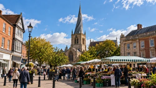
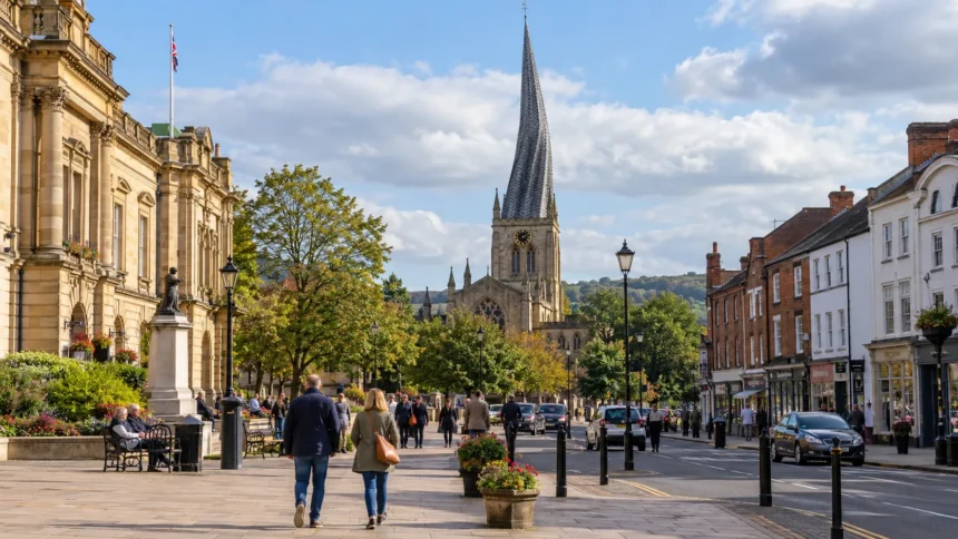
Chesterfield is known for its rich history, unique architecture, and cultural landmarks. The most iconic attraction is the Church of St. Mary and All Saints, famously known as the Crooked Spire.

This 14th-century parish church has a twisted spire that leans nearly 2.5 metres (8 feet) off centre, making it a well-known symbol of the town.

Other notable attractions include:

  • Chesterfield Market: One of the largest open-air markets in England, dating back to 1204. It operates several days a week and attracts both locals and tourists.
  • Hardwick Hall: A grand Elizabethan country house located near Chesterfield, known for its stunning architecture and historical significance.
  • Bolsover Castle: A nearby heritage site with spectacular views, showcasing England’s medieval and Stuart-era history.
  • Queen’s Park: A beautiful public park with gardens, sports facilities, and a historic cricket ground.

Chesterfield’s attractions highlight its blend of historic significance, cultural heritage, and natural beauty, making it a key tourist destination in Derbyshire.

How is Chesterfield Governed?

Chesterfield operates under a two-tier system of local government, managed by Chesterfield Borough Council and Derbyshire County Council. The borough council is responsible for local services, including:

  • Housing and planning: Managing housing developments and land use.
  • Waste collection and recycling: Overseeing local environmental management.
  • Leisure and culture: Maintaining parks, markets, and recreational services.
  • Business support: Encouraging economic growth in the borough.

Meanwhile, Derbyshire County Council oversees broader services affecting the whole county, such as:

  • Education: Running schools and colleges.
  • Transport and infrastructure: Managing roads, public transport, and highways.
  • Social services: Providing healthcare, support for elderly residents, and community welfare programs.

Chesterfield also has parliamentary representation, forming part of the Chesterfield constituency in the UK Parliament. The town has a strong local identity but remains closely connected to the wider administrative and political framework of Derbyshire.

What Are the Demographics of Chesterfield?

Chesterfield has a population of around 104,000 people, making it the largest town in Derbyshire. The town has historically been shaped by industrial development, and today, it reflects a mix of urban and rural characteristics.

Key demographic features include:

  • Age distribution: Chesterfield has an aging population, with around 19% aged 65 and above, slightly higher than the UK average.
  • Ethnic diversity: Around 4% of the population belongs to ethnic minority groups, lower than the national average. The largest non-White group is classified as “Other White”, including European communities.
  • Employment sectors: The town has transitioned from traditional industries like coal mining and manufacturing to retail, healthcare, and service-based jobs.
  • Economic disparity: While unemployment is generally below the national average, some areas of Chesterfield have higher levels of economic deprivation, particularly former coal-mining districts.

Overall, Chesterfield maintains a strong working-class heritage, with its economy evolving towards modern industries while retaining historical ties to its industrial roots.

What Are the Transport Links in Chesterfield?

Chesterfield’s strategic location makes it a well-connected town within the UK’s transport network. Its proximity to major cities such as Sheffield, Derby, and Nottingham allows easy access for commuters and businesses.

1. Road Connections

  • The M1 motorway (Junction 29) is just six miles away, providing direct routes to London and the North.
  • The A61 and A619 serve as key local roads, linking Chesterfield with surrounding towns.

2. Rail Network

Chesterfield Railway Station is on the Midland Main Line, offering direct services to:

  • London St Pancras (under 2 hours)
  • Sheffield (12 minutes)
  • Leeds, Birmingham, and Manchester

The station also serves regional routes, making it a crucial hub in Derbyshire.

3. Public Transport

  • A well-connected bus network links Chesterfield to smaller towns in Derbyshire.
  • National Express and Stagecoach provide long-distance coach services to other UK regions.

Chesterfield’s central position, strong transport infrastructure, and easy access to major UK routes make it a key transit hub for both local residents and businesses.

How Does Chesterfield Compare to Other Derbyshire Towns?

How Does Chesterfield Compare to Other Derbyshire Towns

Chesterfield stands out as the largest town in Derbyshire, but it has distinct characteristics compared to other major towns in the county.

Feature Chesterfield Derby Buxton Matlock
Population 104,000 260,000 22,000 10,000
Economic Base Retail, services, former industry Engineering, manufacturing Tourism, spa town Government, tourism
Notable Landmark Crooked Spire Church Derby Cathedral The Crescent Heights of Abraham
Tourism Appeal Moderate Moderate High (Peak District) High (Historic sites)
Transport Links Strong (M1, Rail) Very strong (Rail, M1) Limited rail, road links Moderate (Local bus, rail)

While Derby is the county’s only city and a major industrial centre, Chesterfield remains Derbyshire’s most economically diverse town, balancing urban development, history, and accessibility.

In contrast, Buxton and Matlock have more tourism-driven economies due to their proximity to the Peak District National Park.

Chesterfield’s unique mix of heritage, industry, and strong transport links makes it a key player in Derbyshire’s regional economy.

Why is Chesterfield Important in Derbyshire?

Why is Chesterfield Important in Derbyshire

Chesterfield plays a crucial role in Derbyshire’s economy, transport network, and cultural heritage. As the largest town in the county, it serves as a key commercial hub, providing employment, retail, and services to thousands of residents and visitors.

What is the Economic Significance?

  • Historically, Chesterfield was an industrial powerhouse, with industries such as coal mining, ironworks, and engineering shaping its growth.
  • Today, the town has diversified its economy, with major employment sectors including retail, healthcare, education, and professional services.
  • The Markham Vale Business Park, located near Junction 29A of the M1 motorway, is a modern development that attracts new industries and investment.

What Are the Key Aspects of Transport and Connectivity?

  • Chesterfield’s strategic location in the East Midlands makes it a key transport hub, with road and rail links connecting it to major UK cities.
  • The Midland Main Line railway and the M1 motorway provide easy access to London, Sheffield, Nottingham, and Leeds.

What is the Cultural and Historical Influence?

  • Chesterfield is home to Derbyshire’s largest open-air market, which has been a centre of trade since 1204.
  • The town’s Crooked Spire Church is a significant landmark, drawing visitors from across the country.
  • Nearby heritage sites like Bolsover Castle and Hardwick Hall add to Chesterfield’s tourism appeal.

Chesterfield’s combination of economic strength, historical significance, and transport accessibility makes it a vital part of Derbyshire’s regional identity. The town continues to evolve, balancing its industrial past with a modern future in business, culture, and infrastructure development.

Conclusion

Chesterfield is an essential part of Derbyshire, serving as its largest town and a key economic centre. While its industrial past shaped its development, the town has successfully transitioned into a modern hub with strong transport connections and a diverse economy.

Its historical landmarks, such as the Crooked Spire Church and Chesterfield Market, add to its cultural appeal, making it a unique destination in the county.

As part of Derbyshire’s administrative structure, Chesterfield benefits from county-wide governance while maintaining local autonomy.

Its strategic location, rich history, and growing economy ensure that Chesterfield remains a vital part of Derbyshire’s present and future. Whether for business, tourism, or history, Chesterfield continues to be a significant town in the East Midlands.

FAQs

What county is Chesterfield officially part of?

Chesterfield is officially part of Derbyshire, an administrative and historic county in the East Midlands of England.

Is Chesterfield considered a city or a town?

Chesterfield is a town but also functions as a borough, governed by Chesterfield Borough Council within Derbyshire.

What is Chesterfield most famous for?

Chesterfield is best known for its Crooked Spire Church, a historic market, and its strong industrial heritage.

How far is Chesterfield from major UK cities?

Chesterfield is 24 miles from Derby, 11 miles from Sheffield, and 38 miles from Nottingham, making it well-connected.

How did Chesterfield get its name?

The name originates from Old English words meaning a Roman fort by the river, reflecting its early settlement history.

What industries have shaped Chesterfield’s economy?

Chesterfield’s economy was historically based on coal mining, ironworking, and manufacturing, but now includes retail and services.

Does Chesterfield have good transport links?

Yes, Chesterfield is well connected by the M1 motorway, railway services to major cities, and a strong local bus network.

Subscribe to Our Newsletter

Subscribe to our newsletter to get our newest articles instantly!

[mc4wp_form]
TAGGED: what county is chesterfield in, what county is chesterfield in london, what county is chesterfield in map, where is chesterfield on a map
Share this Article
Twitter Copy Link Print
Previous Article full body massage london Top 10 Full Body Massage London: Best Places for Ultimate Relaxation
Next Article what county is salford in What County is Salford In? | Location, History, & Key Facts

Editor's Pick

Top 10 Hotels in Bristol - Experience True Comfort and Hospitality

Top 10 Best Hotels in Bristol

Welcome to Bristol, a vibrant city in the southwest of England. Whether you're visiting for business or pleasure, you'll need…

By Olivia James 17 Min Read
The Best Things to Do in Cornwall - Get Ready to Fall in Love
The Best Things to Do in Cornwall

Cornwall is a land of enchanting landscapes, picturesque villages and stunning coastlines.…

33 Min Read
Best Things to Do in North London - Top 15
Best Things to Do in North London – Top 15

Welcome to the vibrant and diverse world of North London! Whether you're…

30 Min Read

Top Writers

Olivia James 441 Articles

Opinion

What Taxes Do Small Businesses Pay in the UK

What Taxes Do Small Businesses Pay in the UK?

Small businesses in the UK may have to pay several…

July 30, 2026

Top 10 Best Places to Stay in Somerset

Welcome to Somerset, a picturesque county…

November 16, 2023

Top 10 Best Place to Visit in Somerset

Welcome to our ultimate guide to…

July 1, 2023

Top 10 Best Things to Do in Somerset

Somerset is one of England's most…

June 26, 2023

Top 12 Best Dog Friendly Beaches in Somerset

Looking for a pawfect day out…

June 17, 2023

You Might Also Like

Tarta de Choclo
Travel

Best Tarta de Choclo Near Me in South West London

Searching for the best tarta de choclo near me in South West London is not as straightforward as finding pizza,…

14 Min Read
Modern London single-deck bus travelling through South London on a new limited-stop route.
Travel

SL15 Bus Route Confirmed For Clapham Junction–Eltham In 2027

The SL15 bus route has been confirmed as a new limited-stop Superloop service between Clapham Junction and Eltham. It is…

21 Min Read
Multi-Day Walking Holidays in the South West England That Combine Nature & History
Travel

Multi-Day Walking Routes in the South West England That Combine Nature & History

Walking is one of the best activities if you are seeking some outdoor fun and adventure without having to push…

9 Min Read
Diamond Bus Number 57 Cancelled
Travel

Diamond Bus Number 57 Cancelled: Replacement Routes Detailed

Diamond bus number 57 has been cancelled, with the Stourbridge-to-Wall Heath service withdrawn after its final journeys on Saturday, 18…

17 Min Read
Southwestmag-logo Southwestmag-logo-black

SouthWestMag: The Best UK south-west region Magazine which covers news and updates and provides tips and guides to tourists and local people. 

Categories

  • Home
  • Business
  • Education
  • Finance
  • Home & Living
  • Technology
  • Travel
  • Lifestyle
  • South West UK
    • Bristol
    • Cornwall
    • Devon
    • Dorset
    • Gloucestershire
    • Somerset
  • Contact Us

Trending

how digital nomads can find the perfect match on bumble

Buzzing Towards Love – How Digital Nomads Can Find The Perfect Match On Bumble?

Fernando Raymond By Fernando Raymond October 28, 2023
Top 8 Best Steak Restaurants in South West London
Top 14 Universities in the South West of England
Best Pubs in Weymouth – Top 10 (Maps Included)
Best 15 Things to Do in Leicester

© South West Mag 2026. All Rights Reserved.

Table of Contents

×
  • What County is Chesterfield In?
  • Is Chesterfield a Town or a Borough?
  • Where is Chesterfield on the UK Map?
  • What Are the Nearest Towns to Chesterfield?
    • 1. Staveley (4 miles southwest)
    • 2. Clay Cross (5 miles north)
    • 3. Dronfield (5 miles southeast)
    • 4. Bolsover (6 miles west)
    • 5. Matlock (9 miles northeast)
  • What Are the Nearest Cities to Chesterfield?
    • 1. Sheffield (10 miles south)
    • 2. Derby (22 miles north)
    • 3. Nottingham (23 miles northwest)
    • 4. Doncaster (23 miles southwest)
    • 5. Manchester (38 miles southeast)
    • 6. Leeds (39 miles south)
    • 7. Lincoln (37 miles west)
  • What is the History of Chesterfield’s County Affiliation?
  • What Are the Main Attractions in Chesterfield?
  • How is Chesterfield Governed?
  • What Are the Demographics of Chesterfield?
  • What Are the Transport Links in Chesterfield?
    • 1. Road Connections
    • 2. Rail Network
    • 3. Public Transport
  • How Does Chesterfield Compare to Other Derbyshire Towns?
  • Why is Chesterfield Important in Derbyshire?
    • What is the Economic Significance?
    • What Are the Key Aspects of Transport and Connectivity?
    • What is the Cultural and Historical Influence?
    • Conclusion
  • FAQs
    • What county is Chesterfield officially part of?
    • Is Chesterfield considered a city or a town?
    • What is Chesterfield most famous for?
    • How far is Chesterfield from major UK cities?
    • How did Chesterfield get its name?
    • What industries have shaped Chesterfield’s economy?
    • Does Chesterfield have good transport links?
→ Index

Removed from reading list

Undo
Welcome Back!

Sign in to your account

Lost your password?