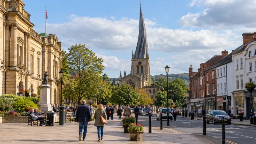
Chesterfield is a large market town in Derbyshire, within the East Midlands region of England. It lies in the north-east of the county, around 11 miles south of Sheffield and close to the boundary between Derbyshire and South Yorkshire.
The town is part of the Borough of Chesterfield and remains within Derbyshire for administrative and geographic purposes. Although its close relationship with Sheffield sometimes causes confusion over its county, Chesterfield is not in South Yorkshire.
Known for its Crooked Spire, historic market, industrial heritage and proximity to the Peak District, Chesterfield occupies an important position between northern Derbyshire and South Yorkshire.
| Feature | Details |
| County | Derbyshire |
| Region | East Midlands |
| Country | England |
| Local District | Borough of Chesterfield |
| County Council | Derbyshire County Council |
| Closest Major City | Sheffield |
| Post Town | Chesterfield |
| Main Postcodes | S40 to S45 |
| Dialling Code | 01246 |
Is Chesterfield In Derbyshire Or South Yorkshire?
Chesterfield is in Derbyshire, not South Yorkshire.
Confusion often arises because Sheffield is only a short distance north of Chesterfield. The two areas have strong employment, transport, shopping and cultural links, while many residents travel regularly between them.
However, they remain on different sides of the county boundary. Chesterfield belongs to Derbyshire, while Sheffield is in South Yorkshire.
This geographic closeness has created a strong relationship between the two areas without changing Chesterfield’s official county status.
Sheffield is Chesterfield’s closest major city, meaning the relationship is particularly noticeable in commuting patterns and rail connections.
People visiting the wider area may also combine Chesterfield with some of the things to do in Sheffield, especially when travelling across the Derbyshire and South Yorkshire boundary.
Is Chesterfield Part Of The Peak District?
Chesterfield is closely associated with the Peak District, although the main urban area of Chesterfield is outside the Peak District National Park.
The town sits to the east of the national park and provides convenient access to many of its eastern and central areas. This is why Chesterfield is sometimes described as a gateway to the Peak District.
Derbyshire and the Peak District should not be treated as the same geographic area.
Derbyshire is a county containing towns, villages, countryside and urban centres. The Peak District is a protected national park covering a substantial area of Derbyshire while also extending into neighbouring counties.
Buxton is one of the Derbyshire towns more strongly associated with the national park. Outdoor attractions such as Go Ape Buxton in Derbyshire reflect the broader recreational character of the Peak District area.
Chesterfield therefore belongs to Derbyshire and provides access to the Peak District without its central urban area being inside the national park.
Is Chesterfield A Town, Borough Or City?
Chesterfield is officially a town, not a city.
It is also the principal settlement within the Borough of Chesterfield, an administrative local-government district.
The term borough sometimes creates confusion because it refers to the council area rather than changing Chesterfield’s settlement status.
The geographic structure can be understood as:
- Chesterfield Is A Town: This refers to the main urban settlement
- Borough Of Chesterfield Is A District: This is the local-government area
- Derbyshire Is The County: Chesterfield forms part of the wider county
- East Midlands Is The Region: Derbyshire lies within this English region
- England Is The Country: Chesterfield is located in England within the United Kingdom
Chesterfield does not have official city status, although its economic and transport role makes it an important centre for northern Derbyshire.
What Is The Difference Between Chesterfield Town, Chesterfield Borough And Derbyshire?
The three names describe different levels of geography and administration.
Chesterfield town refers mainly to the built-up settlement centred around the historic market, Crooked Spire and commercial centre.
The Borough of Chesterfield is the administrative district managed by Chesterfield Borough Council. Its boundary covers a wider area than Chesterfield town centre alone.
Derbyshire is the larger county that contains Chesterfield along with places such as Matlock, Buxton, Bolsover and Bakewell.
The hierarchy is:
- Town: Chesterfield
- District: Borough of Chesterfield
- County: Derbyshire
- Region: East Midlands
- Country: England
- Sovereign State: United Kingdom
This distinction is particularly important when considering council services, planning responsibilities, addresses and county boundaries.
Is Chesterfield The County Town Of Derbyshire?
No. Chesterfield is not the county town of Derbyshire.
Matlock is generally recognised as Derbyshire’s county town and is home to the principal headquarters of Derbyshire County Council.
Chesterfield is nevertheless one of the most significant towns in the county. It serves as an important commercial, employment and transport centre for northern Derbyshire.
Derby can also create confusion because its name is closely associated with Derbyshire. Derby is a city and operates as a separate unitary authority, while Matlock performs the traditional county-town role for Derbyshire.
The status of county town therefore does not necessarily belong to the county’s largest or most economically important settlement.
Has Chesterfield Always Been Part Of Derbyshire?
Chesterfield has been associated with Derbyshire for centuries.
The settlement developed close to important historic routes before becoming a significant medieval market town. Its market charter dates to 1204 and helped establish Chesterfield as an important trading centre for surrounding communities.
Industrialisation transformed the town during later centuries. Coal mining, ironworking, engineering and railway development became major parts of Chesterfield’s economy.
These industries also connected the town closely with mining and manufacturing communities elsewhere in northern Derbyshire.
Local-government arrangements and district boundaries have changed over time, but Chesterfield has maintained its historic connection with Derbyshire.
Its proximity to Sheffield has produced strong economic and social links with South Yorkshire, but this has not transferred Chesterfield into South Yorkshire.
How Is Chesterfield Governed In 2026?
As of September 2026, Chesterfield continues to operate through a two-tier local-government structure.
Chesterfield Borough Council deals with services that are primarily local to the borough, while Derbyshire County Council provides larger county-wide services.
Chesterfield Borough Council responsibilities include:
- Housing: Managing council housing and homelessness services
- Planning: Handling local planning applications and development policies
- Waste Collection: Organising household rubbish and recycling collections
- Leisure: Managing local parks, leisure facilities and cultural services
- Economic Development: Supporting regeneration and local businesses
Derbyshire County Council is responsible for areas including:
- Education: Providing strategic education services
- Highways: Managing roads and related infrastructure
- Social Care: Providing adult and children’s social-care services
- Waste Disposal: Handling wider waste-treatment responsibilities
- Libraries: Managing library services across much of Derbyshire
This division means residents may deal with different councils depending on the service they require.
Is Chesterfield’s Local Government Changing?
Significant changes have been proposed for local government across Derbyshire, although the position became less certain during September 2026.
In July 2026, the Government announced plans that would replace the existing Derby and Derbyshire councils with two larger unitary authorities.
Under the proposed model, Chesterfield would join a northern Derbyshire authority alongside Bolsover, Derbyshire Dales, High Peak and North East Derbyshire.
A unitary authority would bring services currently divided between county and district councils under one organisation.
However, the wider local-government reorganisation programme was subsequently paused for review in September 2026.
Therefore, Chesterfield continues to be served by Chesterfield Borough Council and Derbyshire County Council while the future arrangements are reviewed.
What Will Change For Chesterfield From 2028?
The earlier reorganisation proposals suggested major changes from 1 April 2028.
Under the proposed northern Derbyshire unitary structure, responsibilities currently divided between Chesterfield Borough Council and Derbyshire County Council would be brought together.
These could include:
- Housing
- Planning
- Education
- Highways
- Social Care
- Waste Services
- Leisure Services
- Other Council Functions
However, because the national reorganisation programme was paused for review in September 2026, the original timetable should not be treated as guaranteed.
One point remains clear regardless of future council arrangements. A change in local-government structure would not automatically move Chesterfield into South Yorkshire or alter its longstanding Derbyshire identity.
Which Towns And Cities Are Closest To Chesterfield?
Chesterfield occupies a useful position in northern Derbyshire, close to South Yorkshire and within reach of several major East Midlands destinations.
| Place | General Direction | Relationship To Chesterfield |
| Sheffield | North | Closest major city |
| Dronfield | North | Derbyshire town between Chesterfield and Sheffield |
| Staveley | North-east | Closely connected settlement |
| Bolsover | East | Historic Derbyshire town |
| Clay Cross | South | Derbyshire town on the A61 corridor |
| Matlock | South-west | County town of Derbyshire |
| Derby | South | Major city associated with Derbyshire |
| Nottingham | South-east | Major East Midlands city |
Sheffield has the strongest major-city relationship with Chesterfield because of the short distance between them.
Visitors spending time on both sides of the county boundary can also find a wide selection of hotels in Sheffield, while Chesterfield itself provides a convenient base for exploring Derbyshire.
How Is Chesterfield Connected To Sheffield, Derby And Nottingham?
Chesterfield’s position gives it strong transport links with several major cities.
Sheffield lies directly to the north and is particularly important for commuting, employment, education and leisure. Direct rail services make journeys between Chesterfield and Sheffield relatively quick.
Derby lies to the south and provides another important connection within the wider Derbyshire area.
Nottingham is situated to the south-east and forms part of Chesterfield’s wider East Midlands connections.
Chesterfield railway station is served by intercity and regional services, while the nearby M1 motorway provides road access towards Sheffield, Nottingham and destinations farther north and south.
The A61 is also important locally, particularly for journeys between Chesterfield and Sheffield.
These connections help Chesterfield serve as a link between northern Derbyshire, South Yorkshire and the wider East Midlands.
What Is Chesterfield Known For?
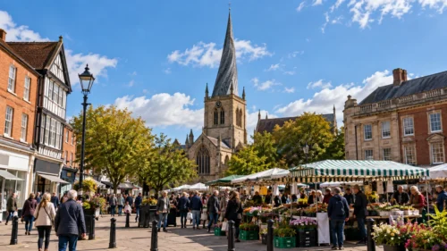
Chesterfield is best known for the Crooked Spire of the Church of St Mary and All Saints.
Its twisted and leaning appearance has become the town’s most recognisable landmark and one of the distinctive historic sights associated with Derbyshire.
Chesterfield is also known for:
- Chesterfield Market: A market tradition stretching back to the medieval period
- Industrial Heritage: Coal mining, engineering and manufacturing played major roles in local development
- Chesterfield Canal: A historic waterway reflecting the area’s industrial history
- Queen’s Park: An important public park close to the centre
- Peak District Access: Chesterfield provides convenient access to countryside west of the town
- Historic Surroundings: Bolsover Castle and Hardwick Hall are among the notable attractions in the wider area
Its combination of history, countryside access and transport links makes Chesterfield a useful base for travellers exploring some of the wider places to go in England, particularly destinations across Derbyshire and the Peak District.
Why Is Chesterfield Important To Derbyshire?
Chesterfield functions as an important centre for northern Derbyshire.
Its shops, businesses, public services, railway station and road network serve people living both inside and outside the borough.
Historically, Chesterfield’s economy depended heavily on coal mining, engineering and manufacturing. These industries influenced the development of both the town and neighbouring communities.
Today, the economy is more varied, with employment in areas including:
- Healthcare
- Retail
- Manufacturing
- Education
- Professional Services
- Logistics
- Hospitality
- Public Services
Proximity to the M1 also supports business activity, distribution and commuting.
Chesterfield’s historic market and Crooked Spire add cultural importance, while its position between Sheffield and the Peak District gives it a distinctive role within northern Derbyshire.
How Is Chesterfield Expected To Develop In The Future?
Chesterfield continues to plan for new housing, employment, infrastructure and regeneration.
A significant part of this work is the preparation of the Local Plan 2025 to 2044, which is intended to guide development across the borough over the longer term.
Important priorities are likely to include:
- Housing Growth: Identifying suitable locations for new homes
- Employment Land: Providing space for businesses and investment
- Transport: Improving connectivity and supporting sustainable travel
- Town Centre Development: Encouraging investment while protecting Chesterfield’s character
- Environment: Balancing development with green-space protection
- Heritage: Preserving important historic buildings and local features
Chesterfield’s location should remain one of its main economic advantages. It offers access to Sheffield and the M1 while remaining close to rural Derbyshire and the Peak District.
The future council structure may affect how some services are administered, but Chesterfield’s underlying development needs and its position within Derbyshire will remain important.
Conclusion
Chesterfield is firmly located in Derbyshire, within the East Midlands region of England. It is a town and the principal settlement within the Borough of Chesterfield.
Its proximity to Sheffield explains why some people associate it with South Yorkshire, but the two places remain on opposite sides of the county boundary.
Chesterfield is also closely linked with the Peak District, although its main urban area lies outside the national park.
In 2026, Chesterfield continues to receive local services through Chesterfield Borough Council and Derbyshire County Council while proposed reforms to local government remain under review.
From its medieval market and Crooked Spire to its industrial heritage and modern transport connections, Chesterfield continues to hold an important place within Derbyshire.
FAQs
What County Is Chesterfield In?
Chesterfield is in Derbyshire, a county in the East Midlands region of England.
Is Chesterfield In South Yorkshire?
No. Chesterfield is in Derbyshire, although it lies only a short distance south of Sheffield and the South Yorkshire boundary.
Is Chesterfield In The Peak District?
The main Chesterfield urban area is outside the Peak District National Park, although the town lies close to its eastern side.
Is Chesterfield A City?
No. Chesterfield is officially a town and is the principal settlement within the Borough of Chesterfield.
Is Chesterfield The County Town Of Derbyshire?
No. Matlock is generally recognised as the county town of Derbyshire.
What Region Is Chesterfield In?
Chesterfield is in the East Midlands region of England.
Is Chesterfield Near Sheffield?
Yes. Chesterfield is around 11 miles south of Sheffield and has strong rail, road, employment and economic links with the city.