
Peterborough is in Cambridgeshire, within the East of England. More precisely, Peterborough is a cathedral city and the principal settlement of the City of Peterborough, a unitary authority that remains part of the ceremonial county of Cambridgeshire.
However, the question “what county is Peterborough in?” has a more complicated answer when historic and administrative boundaries are considered.
For centuries, Peterborough was mainly associated with Northamptonshire through the Soke of Peterborough. The Soke became a self-governing administrative county in 1889, joined Huntingdonshire to form Huntingdon and Peterborough in 1965, and became part of Cambridgeshire in 1974.
Another important change followed in 1998, when Peterborough stopped being administered by Cambridgeshire County Council and became a unitary authority. It did not leave Cambridgeshire altogether. Peterborough remains within Cambridgeshire for ceremonial purposes.
Understanding these different layers of geography explains why Peterborough can correctly be described as historically connected with Northamptonshire while being part of modern Cambridgeshire today.
What County Is Peterborough In Today?
Peterborough is currently in the ceremonial county of Cambridgeshire, England. It is also in the East of England region and forms part of the wider Cambridgeshire and Peterborough city region.
The unusual part is its local government arrangement. Peterborough City Council operates as a unitary authority, which means Peterborough does not depend on Cambridgeshire County Council to provide county-level services.
This makes Peterborough’s relationship with Cambridgeshire slightly different from that of many towns and cities elsewhere in the county.
For a simple modern geographical answer, Peterborough can therefore be described as:
Peterborough, Cambridgeshire, England.
For questions about local government, however, the relevant authority is Peterborough City Council rather than Cambridgeshire County Council.
Why Is Peterborough’s County Identity Confusing?
The confusion comes from the fact that the word county can describe several different geographic arrangements.
A historic county reflects long-standing geographical and cultural boundaries. A ceremonial county is used for purposes such as lieutenancy. An administrative area determines which council provides local government services.
Peterborough does not have the same answer for all three.
| Type Of Area | Peterborough’s Position |
| Country | England |
| English Region | East of England |
| Ceremonial County | Cambridgeshire |
| Historic County | Mainly Northamptonshire |
| Former Administrative Area | Soke of Peterborough |
| 1965–1974 County | Huntingdon and Peterborough |
| Current Local Authority | Peterborough City Council |
| Authority Type | Unitary Authority |
| City Region | Cambridgeshire and Peterborough |
The wider explanation of historic ceremonial and administrative counties helps show why an English city can have one historic county identity while belonging to a different modern administrative structure.
Peterborough is a particularly clear example because several major local government reorganisations affected the area during the 20th century.
Why Was Peterborough Historically Part Of Northamptonshire?
Most of Peterborough’s historic connection with Northamptonshire comes from the Soke of Peterborough.
The Soke was a liberty within the historic county of Northamptonshire. It had significant judicial and administrative independence from the rest of the county long before modern local government was established.
Peterborough therefore belonged geographically to Northamptonshire while operating differently from most other parts of the county.
The Soke had separate legal arrangements and its own quarter sessions. This gave the area a strong tradition of local autonomy.
When elected county councils were introduced during the late 19th century, the Soke did not simply come under Northamptonshire County Council. Instead, it received its own administrative county council.
From 1889 until 1965, the Soke of Peterborough County Council governed the area.
That arrangement explains why describing historic Peterborough simply as an ordinary part of Northamptonshire misses an important detail. It was historically within Northamptonshire, but it had a considerable degree of administrative independence.
What Was The Soke Of Peterborough?
The Soke of Peterborough was a historic territory centred on Peterborough and surrounding communities.
The word soke referred to an area associated with particular jurisdictional rights. In Peterborough’s case, these rights helped create a territory that operated with a high degree of independence from the wider county.
Its origins were connected with the influence of Peterborough Abbey and the legal privileges held within the area.
By the 14th century, the Soke had separate quarter sessions from the rest of Northamptonshire. Later administrative reforms preserved much of this distinct identity.
In 1889, the Soke became an administrative county in its own right. Its boundaries were similar, although not identical, to those of the modern City of Peterborough unitary authority.
The comparison with modern Peterborough is important. Today, Peterborough remains ceremonially within Cambridgeshire while having its own unitary council.
Historically, the Soke was geographically within Northamptonshire while being administered separately from Northamptonshire County Council.
Peterborough’s tradition of operating independently within a wider county therefore has deep historical roots.
How Did Peterborough Move From Northamptonshire To Cambridgeshire?
Peterborough did not move directly from Northamptonshire to Cambridgeshire in a single boundary change. Its modern county status developed through several stages.
| Period | Peterborough’s Status |
| Before 1889 | Soke of Peterborough within historic Northamptonshire |
| 1889–1965 | Soke of Peterborough administrative county |
| 1965–1974 | Part of Huntingdon and Peterborough |
| From 1 April 1974 | Part of Cambridgeshire |
| From 1 April 1998 | Peterborough unitary authority within ceremonial Cambridgeshire |
The 1965 Change
In 1965, the Soke of Peterborough was abolished as an administrative county. It was joined with Huntingdonshire to form a new administrative county called Huntingdon and Peterborough.
This is important because Peterborough did not become part of modern Cambridgeshire in 1965. References claiming that it moved straight from Northamptonshire to Cambridgeshire that year miss this intermediate stage.
The 1974 Change
A much larger restructuring of English local government took effect on 1 April 1974. Huntingdon and Peterborough was abolished. The modern Peterborough district was created and became part of the non-metropolitan county of Cambridgeshire.
The district brought together Peterborough and several surrounding urban and rural areas.
The 1998 Change
Peterborough’s administrative position changed again on 1 April 1998. The district was removed from the area administered by Cambridgeshire County Council and became a unitary authority.
This gave Peterborough City Council responsibility for most council services within its area. Peterborough nevertheless remained part of the ceremonial county of Cambridgeshire.
Why Does Peterborough Have Such A Complicated County History?
Peterborough’s complicated county identity developed because historic geography and local government administration changed at different times.
Its starting point was unusual. The Soke already had considerable independence while remaining geographically part of Northamptonshire.
The reforms of 1889 formalised that independence through the Soke’s own county council.
The 1965 reforms then combined Peterborough with Huntingdonshire. Only nine years later, another national reorganisation moved the district into Cambridgeshire.
Peterborough regained a form of administrative independence in 1998 through unitary authority status.
As a result, several statements can appear contradictory while referring to different periods or different definitions:
- Peterborough was historically mainly in Northamptonshire.
- Peterborough was in Huntingdon and Peterborough between 1965 and 1974.
- Peterborough has been part of Cambridgeshire since 1974.
- Peterborough has not been governed by Cambridgeshire County Council since 1998.
- Peterborough remains ceremonially in Cambridgeshire.
- The date and type of county being discussed therefore matter.
Is Peterborough A City, County Or District?
Peterborough is a city, but it is not an English county.
The term City of Peterborough also refers to the wider local government district, which has city status and is governed by Peterborough City Council.
Peterborough became a cathedral city in 1541, when the former abbey church became Peterborough Cathedral.
The modern district was created in 1974 by combining Peterborough with a number of surrounding areas.
City status was continued over the enlarged district.
This means the official City of Peterborough covers considerably more territory than Peterborough’s continuous urban area.
Peterborough should therefore not be called “Peterborough County” when referring to the English city.
That wording can also create international confusion because Peterborough County is an actual county in Ontario, Canada.
What Is The Difference Between Peterborough And The City Of Peterborough?
Peterborough normally refers to the main urban settlement built around the city centre, cathedral and surrounding neighbourhoods. The City of Peterborough is the larger unitary authority area.
It includes the main city as well as villages, rural land and smaller settlements surrounding it.
Urban communities include areas such as Bretton, Dogsthorpe, Eastfield, Fletton, Longthorpe, the Hamptons, the Ortons, Paston, Walton, Werrington and Woodston.
The wider district also reaches communities such as Ailsworth, Barnack, Castor, Deeping Gate, Eye, Glinton, Helpston, Maxey, Northborough, Thorney, Wansford, Wittering and Wothorpe.
This distinction matters when discussing population.
A population figure for the Peterborough urban area will usually be smaller than a figure covering the entire City of Peterborough local authority.
The same distinction also affects elections, council services and geographic statistics.
What Are The Key Facts About Peterborough?
Peterborough’s main geographic and administrative details can be summarised as follows.
| Detail | Peterborough |
| Country | England |
| Region | East of England |
| Ceremonial County | Cambridgeshire |
| Historic Association | Mainly Northamptonshire |
| City Status | 1541 |
| Modern District Established | 1 April 1974 |
| Unitary Authority Since | 1 April 1998 |
| Local Authority | Peterborough City Council |
| Administrative Headquarters | Sand Martin House, Fletton |
| Council Model | Leader and Cabinet |
| Council Leader In 2026 | Shabina Qayyum |
| Civic Mayor For 2026/27 | Chris Harper |
| Area | Around 132 sq mi or 343 km² |
| 2021 District Population | Around 215,700 |
| 2025 Population Estimate | Around 224,757 |
| Demonym | Peterborian |
| Post Town | PETERBOROUGH |
| Postcode Area | PE |
| Main City Postcodes | PE1–PE8 |
| Dialling Code | 01733 |
| ISO 3166-2 Code | GB-PTE |
| GSS Code | E06000031 |
| Standard Time | GMT |
| Summer Time | BST |
Peterborough City Council is currently under no overall control, with the council led through a coalition arrangement.
Where Exactly Is Peterborough In England?
Peterborough occupies an interesting geographic position near the meeting point of Cambridgeshire, Northamptonshire and Lincolnshire.
The wider City of Peterborough district borders North Northamptonshire, Huntingdonshire, Fenland, South Kesteven and South Holland.
Its western side therefore meets Northamptonshire, while areas to the north connect with Lincolnshire. The eastern and southern boundaries meet other parts of Cambridgeshire.
This border position contributes to Peterborough’s mixed geographic identity.
What Is Peterborough’s Landscape Like?
Much of the area around Peterborough is relatively flat.
The city sits close to the western edge of the Fens, a large low-lying landscape stretching across parts of Cambridgeshire, Lincolnshire and neighbouring areas.
Peterborough has consequently been described as a gateway to the Fens.
Some surrounding Fenland lies close to or below sea level, while extensive drainage has transformed land that historically experienced regular flooding.
The River Nene has also been important to the settlement’s development and landscape.
Peterborough experiences the generally maritime climate found across Britain, although its inland East of England location means the area can be relatively dry by UK standards.
Weather observations at Wittering have also recorded some unusually high summer temperatures, including 39.9°C during July 2022.
Is Peterborough In East Anglia Or The Midlands?
Peterborough is officially within the East of England region.
It is also frequently described as part of East Anglia, particularly because of its Cambridgeshire location and relationship with the Fens.
It is not officially part of the East Midlands.
However, Peterborough sits close to Northamptonshire and Lincolnshire and has historic connections extending westwards. This can make its regional identity appear less clear than that of cities deeper inside East Anglia.
The simplest distinction is:
| Question | Answer |
| Official English Region | East of England |
| Ceremonial County | Cambridgeshire |
| Common Broader Geographic Association | East Anglia |
| East Midlands Region | No |
Its position close to several regional and county boundaries is one reason Peterborough has developed strong connections in more than one direction.
How Is Peterborough Governed Today?
Peterborough City Council is the main local authority for the City of Peterborough. It is a unitary authority, meaning one council carries out functions that are divided between county and district councils in two-tier areas.
This covers major responsibilities including children’s services, adult social care, waste, planning, local roads, housing functions and other local public services.
The council’s main administrative headquarters are at Sand Martin House in Fletton.
Peterborough City Council also participates in the wider Cambridgeshire and Peterborough Combined Authority, which deals with strategic issues affecting the wider area.
Some services continue to be organised on a wider geographic basis.
Policing is provided through Cambridgeshire’s police service, while fire and rescue services also operate across Cambridgeshire and Peterborough. Ambulance provision falls within the wider East of England structure.
Peterborough therefore operates independently for many council responsibilities while remaining closely linked with Cambridgeshire through regional and public service arrangements.
Could Peterborough’s Local Government Change Again?
Further local government reorganisation has been considered across Cambridgeshire and Peterborough. Several possible structures were submitted for consideration, including proposals that could change existing council boundaries.
However, the process was paused for review in September 2026, so Peterborough’s present unitary authority remains in place.
For residents and businesses, the important point is that existing council boundaries and services continue to operate unless and until a new arrangement is formally approved and implemented.
Why Isn’t Peterborough Under Cambridgeshire County Council?
Peterborough stopped being administered by Cambridgeshire County Council when it became a unitary authority in 1998. Before that change, the Peterborough district formed part of the non-metropolitan county administered through Cambridgeshire’s two-tier system.
Unitary status transferred county-level functions within the Peterborough area to Peterborough City Council. This did not redraw its ceremonial county.
The distinction is similar to the area’s older history. The historic Soke had considerable administrative independence while remaining geographically connected with Northamptonshire.
Modern Peterborough has administrative independence from Cambridgeshire County Council while remaining ceremonially part of Cambridgeshire.
That parallel helps explain why unitary status does not mean Peterborough has become a separate county.
Which Parliamentary Constituencies Cover Peterborough?
The wider City of Peterborough district is represented through more than one parliamentary constituency. The main Peterborough constituency covers much of the urban city and is represented by Andrew Pakes.
Other parts of the wider local authority fall within North West Cambridgeshire, represented by Sam Carling. The arrangement again shows why Peterborough city and the wider City of Peterborough district should not always be treated as identical geographic areas.
Within local government, the district is divided into electoral wards that elect councillors to Peterborough City Council.
Top Things Peterborough Is Known For
Peterborough is best known for its cathedral, ancient archaeology, railway heritage, River Nene landscape and strong connection with engineering and industrial growth.
Its identity has developed over many centuries. Bronze Age archaeology shows that people lived in the area thousands of years before Peterborough became a recognised city, while its cathedral later established the settlement as an important religious centre.
The arrival of major railway connections during the 19th century transformed Peterborough into an industrial and transport hub. Modern Peterborough combines this history with large green spaces, heritage attractions, sport and an economy supported by engineering, logistics, distribution and services.
1. Peterborough Cathedral
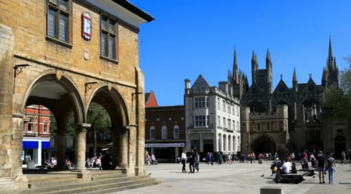
Peterborough Cathedral is the city’s most important historic landmark and one of the main reasons Peterborough has such a prominent place in English religious history.
A monastic community was established on the site during the Anglo-Saxon period, around AD 655. Following later destruction and rebuilding, construction of much of the present cathedral began in the 12th century.
Its vast west front is one of its most distinctive architectural features, while the building contains elements from several periods of medieval development.
The cathedral is also closely associated with Katharine of Aragon, the first wife of Henry VIII, who was buried there following her death in 1536.
Peterborough Abbey was dissolved in 1539, but Henry VIII established Peterborough Cathedral in 1541. This change is closely connected with Peterborough being recognised as a city.
Today, the cathedral remains an active place of worship as well as an important heritage, educational and cultural destination.
2. Flag Fen Archaeology Park
Flag Fen demonstrates that Peterborough’s history began thousands of years before its cathedral and modern urban development.
Located east of the city, the archaeological site is particularly known for its Bronze Age remains. Archaeologists discovered an ancient timber causeway and platform preserved within the wet Fenland landscape.
The remains date back more than 3,000 years and provide valuable evidence about how prehistoric communities lived, travelled and interacted with the surrounding wetlands.
Visitors can also learn about Bronze Age life through reconstructed roundhouses, archaeological displays and artefacts found in the area.
Flag Fen is important because it connects modern Peterborough with a much earlier period of settlement. It also shows how the Fens and River Nene landscape influenced human activity long before the development of the present city.
3. Nene Valley Railway
Peterborough has a strong railway identity, and the Nene Valley Railway helps preserve that heritage.
The heritage railway runs between the Peterborough area and Wansford, passing through the countryside and Nene Park. Stations around Ferry Meadows and Orton Mere make the railway closely connected with some of the city’s most important recreational areas.
Historic steam and diesel locomotives form part of its appeal, allowing visitors to experience an earlier era of British railway travel.
Its significance is particularly appropriate in Peterborough because railways played such an important part in the city’s development.
The arrival of major railway services during the 19th century turned Peterborough from a relatively modest market settlement into an important industrial and transport centre. Modern Peterborough remains one of the better-connected railway locations in eastern England.
4. Nene Park And Ferry Meadows
Nene Park provides a major area of green space along the River Nene and forms an important part of Peterborough’s recreational landscape.
Ferry Meadows, located only a few miles from the city centre, is one of the best-known parts of the park. Its combination of lakes, meadows, woodland and riverside areas provides opportunities for walking, cycling, wildlife watching and outdoor recreation.
Water-based activities are another important feature. Kayaking, paddleboarding, sailing and other activities take place around the lakes, while traffic-free routes make the area accessible to cyclists and walkers.
Nene Park also helps connect the urban city with its surrounding countryside.
For residents, it provides substantial open space close to the city. For visitors, it shows another side of Peterborough beyond its cathedral, railway station and built-up centre.
5. Longthorpe Tower
Longthorpe Tower provides an important link with medieval Peterborough.
The stone tower was added to an existing manor house between approximately 1290 and 1300. Its greatest significance comes from the remarkable wall paintings created around 1330.
These paintings cover religious, secular and symbolic subjects and are considered among the most important surviving examples of medieval domestic wall painting in northern Europe.
The tower was associated with the Thorpe family, who had connections with Peterborough Abbey.
Its location only a short distance from central Peterborough demonstrates how historic buildings and modern development sit close together within the wider city.
Longthorpe Tower complements the cathedral particularly well because it gives visitors a view of medieval domestic life rather than focusing solely on religious architecture.
6. Peterborough United And London Road
Football forms an important part of Peterborough’s modern identity through Peterborough United Football Club, commonly known as the Posh.
The club was formed in 1934 and has played its home matches at London Road since its foundation. Football had already been played at the site for decades before the present club was established.
Peterborough United entered the Football League in 1960 and won the Fourth Division championship during its first league season.
The London Road ground remains close to the city centre and has a capacity of more than 15,000 spectators.
Match days contribute to local activity around the city centre and surrounding businesses, while the club provides Peterborough with a sporting identity recognised well beyond Cambridgeshire.
7. Railway, Brickmaking And Engineering Heritage
Peterborough’s industrial development was heavily influenced by the railway.
Local railway lines began operating during the 1840s, while the opening of the Great Northern Railway route between London and York in 1850 significantly strengthened Peterborough’s position as a transport centre.
Rail access combined with extensive local clay deposits also supported large-scale brickmaking.
Fletton became particularly associated with brick production, and Peterborough developed into one of Britain’s most important brickmaking centres during the industrial period.
Engineering later became another major source of employment, particularly through businesses involved in engines and industrial machinery.
Although Peterborough’s economy has diversified considerably, this heritage continues to influence the city’s identity. Its strategic road and railway position now supports logistics, distribution, manufacturing and other business sectors.
Peterborough Population In 2026: Growth And Demographics
Peterborough has experienced substantial population growth, particularly since its expansion as a New Town during the second half of the 20th century.
The 2021 Census recorded roughly 215,700 residents across the wider City of Peterborough local authority area. The latest official mid-2024 estimate placed the population at approximately 223,665, showing continued growth since the census.
Population figures should be interpreted carefully because the built-up Peterborough urban area is smaller than the entire City of Peterborough unitary authority. The wider district includes numerous villages, rural communities and suburban developments in addition to the central city.
What Has Driven Peterborough’s Population Growth?
Peterborough’s designation as a New Town in 1967 played an important role in its modern expansion. New residential communities were developed around places such as Bretton, Orton and Werrington, while later growth around Hampton created further housing and commercial development.
Employment has also attracted people to the area.
- Logistics And Distribution
- Engineering And Manufacturing
- Retail
- Professional And Financial Services
- Construction
- Public Services
Relatively strong transport links with London, Cambridge, East Anglia and the Midlands have further contributed to the city’s appeal for businesses and workers.
How Diverse Is Peterborough?
Peterborough has become increasingly diverse through both domestic and international migration.
The city has a long-established Italian community linked partly with recruitment into the brickmaking industry during the 20th century. Later migration brought residents from Central and Eastern Europe, South Asia and many other regions.
The 2021 Census also recorded considerable religious diversity. Christianity remained the largest individual religious category, alongside a substantial population identifying with no religion and established Muslim, Hindu, Sikh, Buddhist and other communities.
Continued population growth creates opportunities for Peterborough but also increases pressure on housing, transport, healthcare, schools and other infrastructure. Long-term planning will therefore remain important as the wider city continues to develop.
What Are The Nearest Towns And Villages To Peterborough?
Peterborough occupies an unusual position close to Cambridgeshire’s borders with Northamptonshire and Lincolnshire.
As a result, people living and working in Peterborough frequently interact with communities across several counties. Nearby market towns and villages provide housing, employment, schools, shopping and commuter connections while retaining their own identities.
1. Stamford
Stamford lies northwest of Peterborough and is one of the best-known nearby market towns.
Although closely connected with Peterborough for employment, shopping and transport, Stamford is in Lincolnshire, illustrating how close Peterborough sits to another county boundary.
The town is particularly known for its historic centre, stone-built streets and large collection of listed buildings.
Independent shops, restaurants, schools and professional businesses contribute to its local economy, while road and rail links make movement between Stamford and Peterborough relatively straightforward.
Its proximity makes Stamford an important residential option for people who work in or regularly travel to Peterborough while preferring a smaller market-town environment.
2. Whittlesey
Whittlesey lies east of Peterborough within Cambridgeshire’s Fenland area.
It has traditionally functioned as a market town serving the surrounding agricultural landscape but also has close residential and employment connections with Peterborough.
Road and rail connections allow people to travel between the two places for work, education, shopping and other services.
Whittlesey retains a more compact market-town character than Peterborough while remaining close enough for regular commuting.
Its position also demonstrates how quickly the urban landscape around Peterborough gives way to the flatter agricultural scenery traditionally associated with the Fens.
3. Market Deeping
Market Deeping sits north of Peterborough in Lincolnshire and forms part of the wider Deepings area.
The town has a traditional market-town centre alongside newer residential development.
Its proximity to Peterborough makes it attractive to residents who want access to the employment and transport opportunities of a larger city while living in a smaller settlement.
Road links provide access towards Peterborough, while nearby communities such as Deeping St James expand the wider residential area.
Market Deeping’s location is another reminder that Peterborough functions as an economic and service centre for communities beyond Cambridgeshire itself.
4. Oundle
Oundle lies southwest of Peterborough in North Northamptonshire. The historic market town is particularly known for its attractive centre, traditional buildings and Oundle School, one of England’s long-established independent schools.
The River Nene also passes close to the town, creating a geographic connection with Peterborough further downstream.
Oundle provides local shops, hospitality businesses, schools and services while maintaining a much smaller population and more rural setting than Peterborough.
Its location reinforces Peterborough’s historic and modern connections with Northamptonshire, even though Peterborough itself is now ceremonially in Cambridgeshire.
5. Wansford
Wansford differs from Stamford, Market Deeping and Oundle because it lies within the City of Peterborough unitary authority itself.
The village sits west of the main urban area close to the River Nene and the A1.
Its historic buildings and riverside setting contrast with the more urban character of central Peterborough.
Wansford is also associated with the Nene Valley Railway, strengthening its connection with the area’s railway heritage.
Including Wansford is useful when understanding Peterborough geographically because it demonstrates how the City of Peterborough council area extends well beyond the built-up city into villages and countryside.
Other settlements within the wider district include Castor, Ailsworth, Glinton, Eye, Thorney, Helpston, Wittering and Northborough.
What Are The Cities That Are Close To Peterborough?
Peterborough’s position on major road and railway routes places several important cities within relatively easy reach.
These cities influence employment, business, education, shopping and regional travel, while helping explain Peterborough’s position between East Anglia, the Midlands and London.
1. Ely
Ely lies roughly 24 miles east-southeast of Peterborough across the Fens. Like Peterborough, it is a cathedral city in Cambridgeshire, although Ely is considerably smaller.
Its cathedral dominates the surrounding low-lying Fenland landscape and gives the city a strong historic identity. Rail connections between Peterborough and Ely also make the two cities part of an important route through eastern England.
The comparison is particularly interesting geographically because both cities belong to modern Cambridgeshire but have very different historical and administrative backgrounds.
2. Cambridge
Cambridge is approximately 30 miles southeast of Peterborough and is one of the most important economic and academic centres in the East of England.
Its university, technology sector, science parks, biomedical research and start-up ecosystem give it international significance.
Peterborough and Cambridge are also linked through the wider Cambridgeshire economy, public bodies and regional infrastructure planning.
Rail and road connections support movement between the two areas for employment, education and business.
Cambridge’s rapid economic development also creates wider opportunities and pressures for surrounding parts of Cambridgeshire, including demand for housing, transport improvements and skilled workers.
3. Leicester
Leicester lies west of Peterborough and provides an important connection towards the East Midlands.
The A47 corridor links the Peterborough area westwards, supporting business, freight and regional travel.
Leicester is considerably larger than Peterborough and has major retail, manufacturing, professional services and university sectors.
Connections between the two cities demonstrate Peterborough’s strategic position between the East of England and Midlands rather than at the edge of a single isolated regional economy.
This westward connection is particularly relevant to businesses involved in logistics and distribution.
4. Lincoln
Lincoln lies north of Peterborough and is another historic cathedral city with a strong regional role.
Its cathedral, castle and historic centre make tourism important, while education, engineering, defence-related activities and professional services contribute to the modern economy.
Peterborough’s northern boundary lies close to Lincolnshire, so economic and travel connections between the areas are well established.
Both cities combine major historic landmarks with modern employment and residential growth, although Peterborough has stronger direct connections towards London through the East Coast Main Line.
5. London
London lies approximately 74 miles south of Peterborough and has an important influence on the city’s economy and transport patterns.
Peterborough’s position on the East Coast Main Line provides direct rail access to London, making the capital accessible for business travel, commuting and leisure.
This connectivity has contributed to Peterborough’s appeal as a residential and employment location.
Peterborough’s New Town expansion was also partly connected with accommodating population growth beyond London.
Today, the relationship remains economically important. Businesses in Peterborough can access London’s large commercial market while operating from a location with strong connections to the Midlands, northern England and East Anglia.
How Well Connected Is Peterborough?
Peterborough is particularly well positioned for regional and national travel.
Its development has long been influenced by transport. The railway was central to its industrial growth during the 19th century, while later road improvements strengthened its role as a logistics, distribution and employment centre.
Today, road, rail, buses, cycling routes and access to major airports connect Peterborough with London, East Anglia, the Midlands and northern England.
1. Rail Connections
Peterborough railway station is one of the city’s most important transport assets.
It sits on the East Coast Main Line, providing direct connections towards London and major destinations further north.
Regional rail services also provide access towards places including Ely, Cambridge, Norwich and the Midlands, making Peterborough an important interchange between north-south and east-west journeys.
Rail connectivity supports commuters as well as businesses, particularly those requiring frequent access to London or other regional centres.
Peterborough’s railway importance has deep historic roots. Expansion during the 19th century helped stimulate manufacturing, brickmaking and engineering while allowing products and workers to move efficiently across the country.
2. Road Network
Peterborough benefits from access to several important strategic roads.
The A1 passes close to the western side of the city, providing connections south towards London and north towards Stamford and other destinations.
The A47 provides the main east-west route, connecting Peterborough towards Leicester in the west and Fenland and East Anglia in the east.
The A605 provides additional connections towards communities southwest of the city.
Peterborough also has an extensive system of parkways developed largely during New Town expansion. These routes help connect residential and employment areas without requiring all traffic to pass directly through the historic centre.
Strong road accessibility has helped make Peterborough particularly attractive to distribution, logistics and warehouse businesses.
3. Public Transport And Buses
Local bus services connect Peterborough city centre and railway station with suburban communities and surrounding areas.
Major residential locations such as Bretton, Orton, Hampton and Werrington depend on these connections for access to employment, education, retail and public services.
Routes also extend towards smaller settlements beyond the central urban area.
Peterborough’s relatively dispersed development makes public transport particularly important because the City of Peterborough authority covers far more than the compact historic centre.
Long-term transport planning therefore needs to balance road accessibility with reliable public transport, particularly as new housing and employment areas continue to develop.
4. Cycling And Walking
Peterborough’s generally flat terrain makes cycling practical across many parts of the city. Traffic-free routes run through parts of Nene Park and Ferry Meadows, while cycling connections link recreational areas with nearby residential communities.
National Cycle Route 63 also passes through the Ferry Meadows area.
Walking and cycling routes around the River Nene provide alternatives to travelling entirely by car, particularly for leisure journeys.
The city’s New Town planning also created relatively wide transport corridors and separated pathways in several neighbourhoods.
Continued investment in active travel can become increasingly important as Peterborough’s population grows and demand on the road network increases.
5. Access To Major Airports
Peterborough does not have a major commercial passenger airport within the city, but several airports can be reached through the surrounding road and rail network.
London Stansted, London Luton and East Midlands Airport are among the practical options for domestic and international travel. Different airports may be more convenient depending on destination, airline and onward transport arrangements.
Rail connections through London and other regional centres also broaden the range of airport choices available to residents and businesses.
Although Peterborough cannot match Norwich in having a commercial airport immediately beside the city, its central position between several airport catchment areas gives travellers a range of alternatives.
How Large Is Peterborough And How Many People Live There?
The City of Peterborough local authority covers approximately 343 square kilometres or 132 square miles. Population totals vary depending on whether a figure refers to the urban settlement or the wider unitary authority.
The 2021 Census recorded around 215,700 residents across the wider City of Peterborough area. The latest official mid-2024 estimate places the population at approximately 223,665. A separate 2025 estimate places the district population at around 224,757.
These numbers are not necessarily contradictory because they relate to different reference dates and population estimates. Peterborough has experienced significant long-term population growth.
The area’s population increased rapidly following its designation as a New Town during the 1960s. New housing and employment attracted people from London and elsewhere, while later international migration further changed the city’s demographic profile.
Population forecasts have suggested the wider district could reach around 230,000 residents by 2031 and approximately 240,000 around 2041 if growth continues broadly as projected.
How Diverse Is Peterborough?
Peterborough has become increasingly diverse.
The 2021 Census recorded residents across White, Asian, Black, Mixed and other ethnic groups.
Religious affiliation was also varied. Christianity remained the largest individual category at around 46.2%, followed by no religion at 32.5% and Islam at 12.2%. Smaller proportions identified with Hinduism, Sikhism, Buddhism, Judaism and other religions.
Migration has played a significant role in Peterborough’s development, including historic Italian migration connected with the brickmaking industry and more recent migration from Central and Eastern Europe and other parts of the world.
What Is Peterborough Best Known For?
Peterborough is best known for its cathedral, long history, railway connections, engineering heritage and position beside the Fens.
Peterborough Cathedral
Peterborough Cathedral is the city’s most recognisable historic landmark.
Its origins are linked with the Anglo-Saxon monastery of Medeshamstede, established during the seventh century. The medieval cathedral is particularly known for its large Early English Gothic west front.
Peterborough’s formal city status is also connected with the cathedral. When the former abbey church became a cathedral in 1541, Peterborough came to be regarded as a city.
Flag Fen
Flag Fen provides evidence that human settlement in the Peterborough area stretches back thousands of years.
The archaeological landscape east of the city contains important remains associated with Bronze Age settlement and ritual activity.
It demonstrates that Peterborough’s history began long before its medieval cathedral or modern city development.
Roman Peterborough
The wider area also contains significant Roman heritage.
Durobrivae developed near Water Newton to the west of the modern city, while a substantial Roman fort existed at Longthorpe.
The surrounding Nene Valley later became known for ceramic production, with pottery traded over considerable distances.
Railway And Industrial Heritage
Peterborough’s modern growth accelerated during the 19th century.
Railways began operating locally during the 1840s, but the arrival of the Great Northern Railway route between London and York in 1850 transformed Peterborough into an important railway centre.
Large local clay deposits and railway transport supported major brick production.
The Fletton area became particularly associated with brickmaking, while engineering companies created thousands of jobs during the 20th century.
New Town Development
Peterborough was designated a New Town in 1967.
Expansion included major residential developments around Bretton, Orton, Werrington and later Hampton.
New roads, housing, employment areas and shopping facilities reshaped the city and contributed to substantial population growth.
What County Should Be Used In A Peterborough Address?
For a modern geographic description, Cambridgeshire is appropriate. However, UK postal addressing does not depend on traditional county names in the way it once did. The most important details are the correct post town and postcode.
For Peterborough:
| Address Detail | Information |
| Post Town | PETERBOROUGH |
| Postcode Area | PE |
| Main City Districts | PE1–PE8 |
| Telephone Code | 01733 |
Someone may therefore write an address using Peterborough and the appropriate PE postcode without needing to include Cambridgeshire.
Historic documents can be different. Older records may identify Peterborough with Northamptonshire or Huntingdon and Peterborough depending on when they were produced.
For genealogy, archives or historical property research, the date of the document is therefore important.
Do Peterborough’s Northamptonshire Links Still Appear Today?
Peterborough’s old Northamptonshire connection has not disappeared completely from local identity.
Sport provides one example.
Northamptonshire County Cricket Club historically played first-class matches in Peterborough, including fixtures at the Town Ground during the 20th century.
Local cricket has also maintained connections with Northamptonshire competitions.
Peterborough United Football Club, commonly known as the Posh, provides a stronger modern sporting identity centred directly on the city rather than county boundaries.
Historic institutions, sporting links and older records can therefore still reflect Peterborough’s former Northamptonshire association even though its present ceremonial county is Cambridgeshire.
Are There Other Places Called Peterborough?
Peterborough in Cambridgeshire is not the only place with the name. The most notable international example is Peterborough in Ontario, Canada.
This is particularly important because Canada also has Peterborough County, an administrative area surrounding the Canadian city. There is no equivalent modern “Peterborough County” in England.
When discussing the English location, the correct descriptions are generally Peterborough, City of Peterborough, Peterborough City Council area or Peterborough, Cambridgeshire, depending on the context.
Conclusion
So, what county is Peterborough in? Today, Peterborough is in the ceremonial county of Cambridgeshire, within the East of England.
Its history is more complicated.
Peterborough was historically centred on the Soke of Peterborough within Northamptonshire. The Soke operated as its own administrative county from 1889 until 1965, when it joined Huntingdonshire to form Huntingdon and Peterborough.
That county was abolished in 1974 and Peterborough became part of Cambridgeshire.
Peterborough then became a unitary authority in 1998, removing it from the administrative control of Cambridgeshire County Council while leaving it within ceremonial Cambridgeshire.
The clearest modern description is therefore Peterborough, Cambridgeshire, England, while Northamptonshire remains important when discussing the city’s historic county identity.
FAQs
Is Peterborough In Cambridgeshire?
Yes. Peterborough is in the ceremonial county of Cambridgeshire, although it has its own unitary local authority.
Was Peterborough Ever In Northamptonshire?
Yes. Most of Peterborough was historically within the Soke of Peterborough in Northamptonshire.
When Did Peterborough Leave Northamptonshire?
The Soke of Peterborough was abolished in 1965 and combined with Huntingdonshire to create Huntingdon and Peterborough.
When Did Peterborough Become Part Of Cambridgeshire? Peterborough became part of Cambridgeshire on 1 April 1974 following local government reorganisation.
Why Did Peterborough Become A Unitary Authority?
Peterborough became a unitary authority in 1998, giving Peterborough City Council responsibility for services that had previously also involved Cambridgeshire County Council.
Is Peterborough In East Anglia?
Peterborough is officially in the East of England and is commonly regarded as part of the wider East Anglian area.
Is Peterborough In The East Midlands?
No. Peterborough is officially in the East of England, although its location close to Northamptonshire and Lincolnshire creates strong connections with the Midlands.
Is Peterborough A County?
No. Peterborough is a city and unitary authority district. Its current ceremonial county is Cambridgeshire.
Related Articles: